Weather Alert in California
Lake Wind Advisory issued July 20 at 1:46AM PDT until July 20 at 11:00PM PDT by NWS Reno NV
AREAS AFFECTED: Greater Lake Tahoe Area; Greater Lake Tahoe Area; Western Nevada Basin and Range including Pyramid Lake
DESCRIPTION: * WHAT...For the first Lake Wind Advisory, west winds 15 to 20 mph with gusts up to 30 mph and wave heights of 1 to 3 feet on Lake Tahoe and Pyramid Lake. For the second Lake Wind Advisory, west winds 20 to 25 mph with gusts up to 35 mph and wave heights of 1 to 3 feet on Lake Tahoe and Pyramid Lake. * WHERE...Greater Lake Tahoe Area, and Western Nevada Basin and Range including Pyramid Lake. * WHEN...For the first Lake Wind Advisory, from 2 PM this afternoon to 11 PM PDT this evening. For the second Lake Wind Advisory, from 11 AM to 11 PM PDT Monday. * IMPACTS...Small boats, kayaks and paddle boards will be prone to capsizing and should remain off lake waters until conditions improve.
INSTRUCTION: Check lake conditions before heading out and be prepared for a sudden increase in winds and wave heights. Consider postponing boating activities on the lake until a day with less wind.
Want more detail? Get the Complete 7 Day and Night Detailed Forecast!
Current U.S. National Radar--Current
The Current National Weather Radar is shown below with a UTC Time (subtract 5 hours from UTC to get Eastern Time).

National Weather Forecast--Current
The Current National Weather Forecast and National Weather Map are shown below.

National Weather Forecast for Tomorrow
Tomorrow National Weather Forecast and Tomorrow National Weather Map are show below.

North America Water Vapor (Moisture)
This map shows recent moisture content over North America. Bright and colored areas show high moisture (ie, clouds); brown indicates very little moisture present; black indicates no moisture.

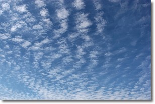
Weather Topic: What are Cirrocumulus Clouds?
Home - Education - Cloud Types - Cirrocumulus Clouds
 Next Topic: Cirrostratus Clouds
Cirrocumulus clouds form at high altitudes (usually around 5 km)
and have distinguishing characteristics displayed in a fine layer of
small cloud patches. These small cloud patches are sometimes referred to as
"cloudlets" in relation to the whole cloud formation.
Cirrocumulus clouds are formed from ice crystals and water droplets. Often, the
water droplets in the cloud freeze into ice crystals and the cloud becomes a
cirrostratus cloud. Because of this common occurrence, cirrocumulus cloud
formations generally pass rapidly.
Next Topic: Cirrostratus Clouds
Weather Topic: What are Cirrus Clouds?
Home - Education - Cloud Types - Cirrus Clouds
 Next Topic: Condensation
Cirrus clouds are high-level clouds that occur above 20,000 feet
and are composed mainly of ice crystals.
They are thin and wispy in appearance.
What do they indicate?
They are often the first sign of an approaching storm.
Next Topic: Condensation
Current conditions powered by WeatherAPI.com


