Weather Alert in California
Lake Wind Advisory issued July 20 at 1:46AM PDT until July 20 at 11:00PM PDT by NWS Reno NV
AREAS AFFECTED: Greater Lake Tahoe Area; Greater Lake Tahoe Area; Western Nevada Basin and Range including Pyramid Lake
DESCRIPTION: * WHAT...For the first Lake Wind Advisory, west winds 15 to 20 mph with gusts up to 30 mph and wave heights of 1 to 3 feet on Lake Tahoe and Pyramid Lake. For the second Lake Wind Advisory, west winds 20 to 25 mph with gusts up to 35 mph and wave heights of 1 to 3 feet on Lake Tahoe and Pyramid Lake. * WHERE...Greater Lake Tahoe Area, and Western Nevada Basin and Range including Pyramid Lake. * WHEN...For the first Lake Wind Advisory, from 2 PM this afternoon to 11 PM PDT this evening. For the second Lake Wind Advisory, from 11 AM to 11 PM PDT Monday. * IMPACTS...Small boats, kayaks and paddle boards will be prone to capsizing and should remain off lake waters until conditions improve.
INSTRUCTION: Check lake conditions before heading out and be prepared for a sudden increase in winds and wave heights. Consider postponing boating activities on the lake until a day with less wind.
Want more detail? Get the Complete 7 Day and Night Detailed Forecast!
Current U.S. National Radar--Current
The Current National Weather Radar is shown below with a UTC Time (subtract 5 hours from UTC to get Eastern Time).

National Weather Forecast--Current
The Current National Weather Forecast and National Weather Map are shown below.

National Weather Forecast for Tomorrow
Tomorrow National Weather Forecast and Tomorrow National Weather Map are show below.

North America Water Vapor (Moisture)
This map shows recent moisture content over North America. Bright and colored areas show high moisture (ie, clouds); brown indicates very little moisture present; black indicates no moisture.

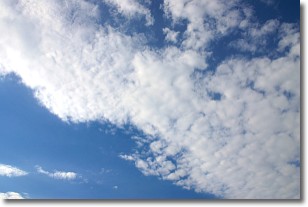
Weather Topic: What are Stratus Clouds?
Home - Education - Cloud Types - Stratus Clouds
 Next Topic: Wall Clouds
Stratus clouds are similar to altostratus clouds, but form at a
lower altitude and are identified by their fog-like appearance, lacking the
distinguishing features of most clouds.
Stratus clouds are wider than most clouds, and their base has a smooth, uniform
look which is lighter in color than a nimbostratus cloud.
The presence of a stratus cloud indicates the possibility of minor precipitation,
such as drizzle, but heavier precipitation does not typically arrive in the form
of a stratus cloud.
Next Topic: Wall Clouds
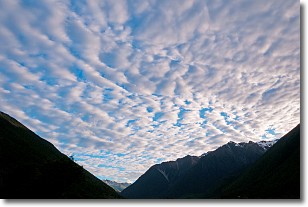
Weather Topic: What are Altocumulus Clouds?
Home - Education - Cloud Types - Altocumulus Clouds
 Next Topic: Altostratus Clouds
Similar to cirrocumulus clouds, altocumulus clouds are
characterized by cloud patches. They are distinguished by larger cloudlets
than cirrocumulus clouds but are still smaller than stratocumulus clouds.
Altocumulus clouds most commonly form in middle altitudes (between 2 and 5 km)
and may resemble, at times, the shape of a flying saucer.
These uncommon formations, called altocumulus lenticularis, are created by uplift
in the atmosphere and are most often seen in close proximity to mountains.
Next Topic: Altostratus Clouds
Current conditions powered by WeatherAPI.com


