Weather Alert in Minnesota
Air Quality Alert issued July 18 at 2:29PM CDT by NWS Duluth MN
AREAS AFFECTED: Koochiching; North St. Louis; Northern Cook/Northern Lake; North Itasca; Central St. Louis; Southern Lake/North Shore; Southern Cook/North Shore; North Cass; South Itasca; South Cass; Crow Wing; Northern Aitkin; South Aitkin; Carlton/South St. Louis; Pine
DESCRIPTION: * WHAT...The Minnesota Pollution Control Agency has issued an Air Quality Alert for fine particles pollution. The Air Quality Index (AQI) is expected to reach the Purple or Very Unhealthy category. * WHERE...North central, northeast, and northwest Minnesota. * WHEN...1 PM CDT Saturday until 9 AM CDT Monday. * IMPACTS...The risk of health effects is increased for everyone. * ADDITIONAL DETAILS...Heavy surface smoke from Canadian wildfires will drift south into Minnesota over the next several days. This smoke will initially impact far northern Minnesota early Saturday afternoon and then spread south and east through the rest of the day and into the evening. Smoke lingers across the region on Sunday with light winds in place, and then exits back to the north through Monday morning. The highest smoke concentrations are expected to be across far northern Minnesota and the Arrowhead region from Saturday into Sunday.
INSTRUCTION: Sensitive groups, such as people with lung disease (including asthma), heart disease, and children and older adults, should avoid all physical activities outdoors. The general public should avoid prolonged or heavy exertion. Reduce or eliminate activities that contribute to air pollution, such as outdoor burning, and use of residential wood burning devices. Reduce vehicle trips and vehicle idling as much as possible. Keep windows closed overnight to prevent smoke from getting indoors.
Want more detail? Get the Complete 7 Day and Night Detailed Forecast!
Current U.S. National Radar--Current
The Current National Weather Radar is shown below with a UTC Time (subtract 5 hours from UTC to get Eastern Time).

National Weather Forecast--Current
The Current National Weather Forecast and National Weather Map are shown below.

National Weather Forecast for Tomorrow
Tomorrow National Weather Forecast and Tomorrow National Weather Map are show below.

North America Water Vapor (Moisture)
This map shows recent moisture content over North America. Bright and colored areas show high moisture (ie, clouds); brown indicates very little moisture present; black indicates no moisture.

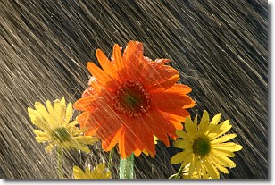
Weather Topic: What is Precipitation?
Home - Education - Precipitation - Precipitation
 Next Topic: Rain
Precipitation can refer to many different forms of water that
may fall from clouds. Precipitation occurs after a cloud has become saturated to
the point where its water particles are more dense than the air below the cloud.
In most cases, precipitation will reach the ground, but it is not uncommon for
precipitation to evaporate before it reaches the earth's surface.
When precipitation evaporates before it contacts the ground it is called Virga.
Graupel, hail, sleet, rain, drizzle, and snow are forms of precipitation, but fog
and mist are not considered precipitation because the water vapor which
constitutes them isn't dense enough to fall to the ground.
Next Topic: Rain
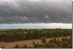
Weather Topic: What are Shelf Clouds?
Home - Education - Cloud Types - Shelf Clouds
 Next Topic: Sleet
A shelf cloud is similar to a wall cloud, but forms at the front
of a storm cloud, instead of at the rear, where wall clouds form.
A shelf cloud is caused by a series of events set into motion by the advancing
storm; first, cool air settles along the ground where precipitation has just fallen.
As the cool air is brought in, the warmer air is displaced, and rises above it,
because it is less dense. When the warmer air reaches the bottom of the storm cloud,
it begins to cool again, and the resulting condensation is a visible shelf cloud.
Next Topic: Sleet
Current conditions powered by WeatherAPI.com


