Weather Alert in Pennsylvania
Special Weather Statement issued July 20 at 10:06AM EDT by NWS State College PA
AREAS AFFECTED: Potter; Tioga; Northern Lycoming; Sullivan; Southern Lycoming; Columbia
DESCRIPTION: A few Strong thunderstorms are expected to accompany the passage of a cold front this afternoon. The storm at any one location will be brief and last only 10 to 15 minutes as they move from northwest to southeast across the region at 20 to 25 mph. The best chance for a thunderstorm accompanied by wind gusts of 40 to 50 mph will be between 1130 AM and 145 PM across Potter and Tioga Counties, 145 PM to 330 PM over Lycoming and Sullivan Counties and 330 to 5 pm across Columbia County. A few of the storms could intensify, and make localized damaging wind gusts of 55 to 65 mph. Be certain to monitor local radio stations and available media sources for additional information and possible warnings from your National Weather Service.
INSTRUCTION: N/A
Want more detail? Get the Complete 7 Day and Night Detailed Forecast!
Current U.S. National Radar--Current
The Current National Weather Radar is shown below with a UTC Time (subtract 5 hours from UTC to get Eastern Time).

National Weather Forecast--Current
The Current National Weather Forecast and National Weather Map are shown below.

National Weather Forecast for Tomorrow
Tomorrow National Weather Forecast and Tomorrow National Weather Map are show below.

North America Water Vapor (Moisture)
This map shows recent moisture content over North America. Bright and colored areas show high moisture (ie, clouds); brown indicates very little moisture present; black indicates no moisture.

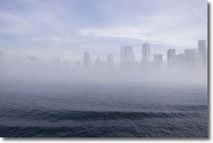
Weather Topic: What is Fog?
Home - Education - Cloud Types - Fog
 Next Topic: Fractus Clouds
Fog is technically a type of stratus cloud, which lies along the
ground and obscures visibility.
It is usually created when humidity in the air condenses into tiny water droplets.
Because of this, some places are more prone to foggy weather, such as regions
close to a body of water.
Fog is similar to mist; both are the appearance of water droplets suspended in
the air, but fog is the term applied to the condition when visibility is less than 1 km.
Next Topic: Fractus Clouds
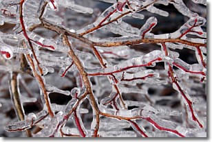
Weather Topic: What is Freezing Rain?
Home - Education - Precipitation - Freezing Rain
 Next Topic: Graupel
Freezing rain is a condition where precipitation which has fallen in the form of
water droplets reaches temperatures which are below freezing and freezes upon
coming into contact
with surface objects. The result of this precipitation is a glaze of ice which
can be damaging to plants and man-made structures. A severe onset of freezing
rain which results in a very thick glaze of ice is known as an ice storm.
Next Topic: Graupel
Current conditions powered by WeatherAPI.com


